THE SOILS
The soils in the Bay have been formed by weathering (dominantly oxidation) of the parent sedimentary rocks, ie from the 60m year old siltstones and from its underlying (!) 20m year old Waitemata sandstones.
Waitemata sandstones weather to form soils which are, for engineering as well as gardening purposes, very similar to weathered 200m year old Greywackes. Most of them have rust-coloured, tan and yellow subsoils. Both can also undergo “red weathering” in which reddish clays are formed. The redness comes from another (of the many) iron oxides. The red claystones/mudstones can look volcanic but they aren’t. Landslips on road berms can commonly be seen to involve these reddish materials while adjacent rust-coloured, tan and yellow, subsoils continue to be stable although having the same slope steepness. As noted above, the Greywacke doesn’t occur naturally in Algies or Snells but is very common in areas a few km away, and there the “red-weathering” is much more common in Waitematas than in Greywackes. One must go further North to see lots of red-weathering in Greywackes.
Because road cuttings and building foundations on both Waitemata sandstones and Greywackes have been common in the wider area their engineering behaviour has been observed over many decades and can be designed-for. It is the behaviour of the weathered 60m year old Mangakahia siltstones which is “odd” and most of the houses and roads in Algies Bay (and much of Snells) are on them.
Firstly they have much higher seasonal shrink/swell. This occurs with seasonal changes in dampness and is therefore only of real concern in the top 600mm or so.
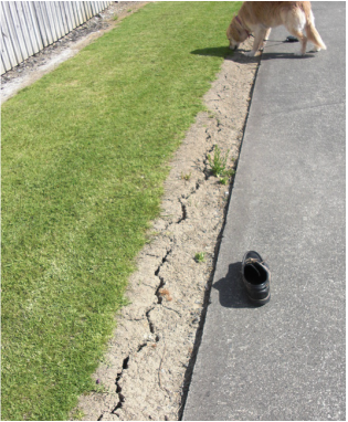
Shrinkage cracks on bared soil – weathered Mangakahia/Onerahi materials.
Organic (black) topsoils do not shrink/swell much or crack and one of their desirable features is that they shade the underlying subsoils and thereby reduce cracking in them.
Furthermore, the subsoils below topsoils don’t dry out as much seasonally, but the cumulative effect of shrink/swell in the top 500mm of subsoils can appear as significant rise/fall of the ground surface.
For house foundations, the obvious way to cope with rise/fall of the ground surface and cracking of the subsoils is to take foundations deeper. This applies to foundations in weatheresd Greywacke as well as in weathered Waitemata rocks but for buildings on the weathered siltstones in Algies (and Snells) shrink/swell is even more significant. The NZ Standard relevant to light timber-framed structures (NZS 3604) requires foundations for such structures on Waitemata Group rocks and greywacke to be taken a minimum of 600mm deep rather than the 450mm allowed on most other soils. The weathered siltstones call for even deeper allowance for shrink/swell and site-specific design(1) .
Similarly, roads need deeper base course if over our weathered siltstones. The sewer manholes in the footpath on Mahurangi East Road have all risen relative to the adjacent concrete footpath, or rather the footpath has sunk more than the manholes have, presumably because the sewers and manholes are supported on deeper ground which experiences less seasonal shrink/swell.
Some of the older timber-framed houses in the Bay are on “building blocks” which extend only about 150 - 200mm below the surface. Many houses sitting on them experience seasonal distortions which cause doors and windows to jam, cracks in plaster walls and ceilings etc etc. One homeowner planed a bit off the top of his front door in dry seasons and off the bottom of it in wet ones!
As shown in the photograph above, soil shrinkage in dry seasons commonly leads to cracking at the ground surface particularly where the soil surface is exposed to sun(2) . This can be serious where grass and weeds are sprayed/killed to facilitate mowing (or for whatever reason) and very serious when done along a fence-line running up/down slope. That can lead to “tunnel-gully-erosion” when the cracks link up to form a continuous crack running up/down slope. Summer showers send water into the crack and the water runs downslope along an initially small tunnel at the level of the base of the crack(s). This becomes enlarged by scouring and eventually the soil above it falls in and a gully is formed.
This tunnel-gully-erosion is a very common type of soil loss in pastoral hill country, particularly in the East Cape and Hawkes Bay areas and in much of the non-volcanic North Island(3) . It is not just a Snells/Algies issue. It is commonly serious in our siltstone soils (in some cases siltstone which has undergone mechanical slaking and little soil development) and less so in soils formed on Waitemata Group rocks.
In the example in the photo, caving-in of the tunnels has taken place in a few places which are linked hydrologically by tunnels which will experience scour so that in time the topsoil above them will collapse and a gully will be formed.
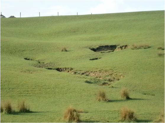
Tunnel-gully-erosion developing in pasture beside Sandspit Road.
In this case in Whangaripo clay loam weathered from a siltstone bed within Waitemata Group rock.
In this case in Whangaripo clay loam weathered from a siltstone bed within Waitemata Group rock.
Tunnel gully erosion has also been observed with water emerging on the Beach after running in tunnels below steep fences. Dr Toan of Beca Carter Consultants reported this in 1980 and it has been observed since. In 1980 it was probably more obvious because the trees and shrubs which now adorn most Lots would not have been as well established, to (a) shade the soils and (b) block the development of the tunnels with roots.
Tunnel gully erosion doesn’t occur so readily in forests because the soils are shaded. The preliminary shrinkage cracking is therefore less likely to develop. Between being forested and the present tree-studded state, the developed land in the Bay was in pasture. Fortunately there were few fences running up/down slope and probably no spraying with Roundup etc during that phase of its history.
Engineers and others commonly talk in terms of soil strengths but that is seldom if ever the issue behind slope stability/instability in these soils. Shrink/swell and cracking are more significant.
Changes in runoff coefficient (infiltration rate) are also significant, as in many soils. Runoff coefficient is the proportion of a rainfall event which runs off rather than soaking into the soil. It is very dependant on the duration and intensity of rainstorms: light showers are absorbed by dry soils and by the surfaces of plants (even grasses) so the runoff coefficient is zero, but as rainfall intensity and duration increase it rises to values like 90%, ie 90% of the rain which falls on an area runs off it.
Heavily-grazed soils become pugged which means a collapse of soil “structure” with a major loss of pore space. This means a loss of infiltration rate as well as loss of permeability.
In some pumice soils this can be spectacular with pugged soils at a farm gate having only a tenth of the infiltration rate of the soils in the middle of a paddock. In areas which the stock can’t get at, infiltration rates can be 10x even the mid-paddock values, ie overall the range can be 10 x 10 = 100 between those extremes. Over-grazing can therefore lead to major gullying by scour both within the soil (as in tunnel-gully-erosion) and on the ground surface, both off-site and on-site. This can be a major issue near Taupo and less spectacular examples may occur in various other soils.
Infiltration rate(4) changes could well be one of the causes of the recent landslips in the Waitemata soils out towards Colliers Point. The pasture on the edge of the cliff was fenced off, probably to stop stock falling off. When grazed intensively the pastures upslope of the fences had their runoff coefficients increased, and their infiltration rates decreased enough for them to fall below rainfall precipitation rates. The water which didn’t infiltrate must flow over the ground to the ungrazed strip between the fence and the clifftop. The ungrazed ground experiences a much more intense rainstorm than it would have and the water infiltrating there must assist in the development of slope failure conditions within the soil. That having been said, the erosion of sea cliffs is a natural phenomenon commonly triggered by erosion by the sea of the base of the slopes/cliffs.
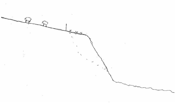
Development of slope failure conditions within soil behind a slope (or cliff) where
the soil above is grazed hard. Instances occur where the fence is left hanging in the air.
the soil above is grazed hard. Instances occur where the fence is left hanging in the air.
When heavily grazed, the infiltration rate of ground upslope of the fence is decreased (ie its runoff coefficient is increased)
while downslope of the fence the infiltration rate is unaffected (or even increased) by trees or rank grass.
Here, slope instability conditions have developed within the soil downslope of the fence.
while downslope of the fence the infiltration rate is unaffected (or even increased) by trees or rank grass.
Here, slope instability conditions have developed within the soil downslope of the fence.
Like all granular media (gravels, sands, silts and clays) soils exhibit dilatancy which is the label given to changes in density/packing of soils when they are distorted. Under high confining pressures dilatancy may occur as an increase in density (decrease in porosity and volume) and under low confining pressures the reverse - decrease in density with increase in porosity and volume. These result in increases and decreases in strength respectively, see under “4” below.
Dilatancy is a familiar phenomenon to those who have “worked up” old putty. The hard putty tries to dilate as its grains try to move past each other. Negative pore pressures develop in the linseed oil and more of it gets sucked into the pores. Conveniently all pores develop the negative oil pressures and the whole mass becomes uniformly softer.
On the Beach at Algies this may be relevant to the appearance of very soft light grey soils where trucks have been working the soil in the presence of plenty of water. Some such patches appeared where trucks etc distorted the soil below the sands when upgrading the sea-wall defences NW of the Central Reserve in late 2014. It will be interesting to see whether the soft patches become firmer as the soil particles sink through the water beside/between them. This will tend to happen because the soil particles are about 2.6 times as dense as water. The weight of even a few hundred millimetres of sand may cause the water which was sucked in by dilatancy (during shearing under the high loads from vehicle wheels) to move out again ie for the soil to undergo consolidation.
Generally the soils in the Bay have a slightly too high pH for good plant growth and mulching is appreciated by most plants. It lowers the pH of the soils, ie makes them less alkaline, ie more acidic.
John Hawley 2014
1 “Specific Engineering Design” by a Chartered Professional Engineer as distinct from design in accordance with Standards such as NZS 3604. Not to be confused with SED when it stands for Small End Diameter – of timber poles for foundations or retaining walls.
2 The effectiveness of shade is felt by people lying in the sun with shade vs without shade (!)
3 See the NZ Land Resource Inventory, NZLRI.
4 A runoff coefficient of 0.3 means that 30% of rainfall runs off ie doesn’t infiltrate. This could be expressed as an Infiltration coefficient of 0.7.
The Astronomer Royal Martin Ryle once commented –
“It is certain that the Universe is more curious than we suppose, and
it is likely that it is more curious than we can suppose.”
That is certainly something astronomers and nuclear scientists have to face but it may well apply also to the behavior of soils.
However we have in the last two centuries progressed well along the path of understanding the ancient and current processes shaping the Earth’s crust: if we work hard enough, and humbly enough, at the challenge, we may progress further.
John Hawley
July 2014
July 2014
