SAND MOVEMENT
From time to time residents in the Bay (particularly new ones) are dismayed to notice that the amount of sand on the Beach is less than they remember seeing.
They soon notice however that the sand comes and goes - sometimes it’s “in” and sometimes it’s “out”. A major storm from the north-east persisting through high tide will stir it up and redeposit it about 20m beyond the low tide mark to form a gently-sloping sand bank. Dinghy owners will then be heard swearing when, after getting the motor started, and moving out a few boat lengths, they run aground.
The sand is brought back by mild wave action over a few weeks or months depending on “wave climate”. So it can be lost during just ONE very stormy high-tide and take months to fully return. Likewise it can stay “in” for many months(1).
Since 1996 Brenda and I have lived on the Beachfront and we have seen two major cyclones with wind from the north-east, Cyclone Fergus(2) in 1998 was followed only 10 days later by Cyclone Dreena. We thought the glass in our ranch-sliders might blow in. In the 16 years since there have been other extreme weather events including an extremely strong blow from the south-east which disturbed yachts “on the hard” at Sandspit and Cyclone Wilma in January 2011 which was more notable for intensity of rainfall than wind strength. None has threatened our ranchsliders as Fergie and Dreena did though.
Students from Auckland University surveyed the profile of the sand at four positions along the Beach over a 5-month period. They found movement but their study period didn’t include major changes from “in” to “out” or vice versa. Generally the depth of sand lost and regained is less than 300mm alongside boat ramps.
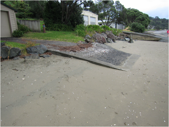
Boat ramp with the sand “in”
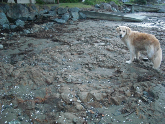
The same boat ramp with the sand “out”
The sand at Algies is partly silica sand and partly shell sand, much of it coming from erosion of looser layers (strata) in the Waitemata Group sandstone cliffs. Accumulations of shell can commonly be seen near high-tide level. (The sand at Mangawhai though mainly silica is different because it was deposited by the Waikato River when it flowed North across the Hauraki Plains and had its mouth north of Little Barrier Island. It includes volcanic materials)
Storms from the north-east have the longest “fetch” before arriving at the Beach and don’t occur very often. Even more seldom do they persist through a high-tide. Waves can be as high as ever at low tide without moving the sand on the Beach. The higher the sand is deposited on the Beach the less likely is it to be removed in storms.
As yachtsmen know, many storm peaks persist for only a few hours. In order to take all the sand out at Algies they must come from the north-east - AND persist through high-tide. Fortunately this doesn’t happen very often, but the fact that it hasn’t occurred over a period of a few years doesn’t mean it won’t ever happen. Having two major north-east gales persist through high tide within a fortnight illustrated the statistical fact that all random distributions include clusters. It will happen again.
Tidal range (as shown on published calendars) varies from 2.7m to 3.7m.
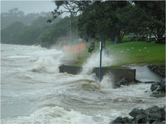
NE storm arrives at Central Reserve during high tide (photo: Shona Duncan)
The excellent stone wall in part of the Central Reserve includes a “bay” in which sand has accumulated and stayed for several years now. This illustrates that once sand has been taken above about the 3.2m high water spring level it will not be removed by anything short of a major storm at high-tide. See above photo of waves striking the old sea wall at the Central Reserve before the sloping stone wall was built there.
The sand in that “bay” will be removed sooner or later by such a storm and come back over the weeks and months after.
The Central Reserve was formed in the late 1950’s by reclamation and by culverting of the stream beside Deerness Crescent to allow the two roads, Alexander and Mariner’s Grove, to be linked to form a crescent. Some residents remember the roads being separated by the stream. Much of the ground of the Reserve and the road through it is on fill placed at that time. Many of the Pohutukawas were planted at that time.
Prior to the major work undertaken by Council in late 2014 erosion immediately above high water mark had in one place exposed an old vehicle chassis and other items. Much of the ground on which the paved concrete vehicle track exists is fill, much of it deposited there to form more level platforms for beach-front houses. Several Lots there were extended seawards by dumping fill and placing large Greywacke rocks to protect it from wave action (see later article on “The Rocks”).
Some sand movement occurs along the beach as well as in and out. This “drift” appears to be dominantly from the south-east (Bethshan) end to the north-west. Certainly that is what can be seen at Omaha Beach where the breakwater introduced in the late 1970’s at its north end had a very positive effect. Also, sand comes and goes at the entrance to Sandspit and yachts with deeper keels have to wait for a tidal rise before entering or leaving there.
Generally, sand on beaches and on the sea floor near beaches is always moving one way or another.
Many ABRRA members have wanted to do something to encourage sand to stay “in”. Sloping sea walls so they don’t reflect wave energy, and doing something about the major flows of rainwater from roofs and roads emerging from drains leading onto the Beach have been suggested. It is possible that a bund constructed at the north-west end could have the effect seen at Omaha Beach and Castor Bay. See later articles for this and other practical matters.
Patterns of sand movement observed over a few months or years may not include extreme movements. It is likely that a major storm (like Fergie and Dreena) from the north-east which persists through high-tide will take out the sand now trapped in the newly-formed “bay” in the Central Reserve but it’ll come back over the following few months.
Heaps of sea grass are another occasional, and fortunately transient, feature of the Beach. These appear most often beyond Bethshan. They’ve probably been coming and going for thousands of years. Like the sand.
It is becoming increasingly clear that in addition to sand being moved out to form a low “bar” and then being slowly brought back in, and the slow movement of sand along the Beach (possibly in both directions) there has been a net loss of sand volume over the last few decades. When the sand is “out” the Beach seems more bare than people remember it ever being. And when it is “in” people feel it is not as deep as it used to be. Some residents have seen sand being washed around the Point at the Highfield end towards Torpedo Bay from where it might be taken to Snells and beyond.
The building of a groyne to inhibit this might be effective. At Omaha, after much study and design work a groyne was built which has obviously arrested longitudinal sand movement and survived many storms.
John Hawley 2014
1 In one period of 3 months about 10 years ago when we had a Rotary Exchange student who was a keen Laser sailor, we were very aware that he had to drop his Laser yacht off a 50mm step from the seaward end of our boat-ramp onto rock. The sand was "out" but not as far out as it has been since then. Since then the sand has been "in" several times and at least a metre up the slope of the ramp with no step at all off the end. See photos above.
2 Commonly referred to as Cyclone Fergie. It was reported to have had wind speeds up to 150 km/hr while Dreena got up to 165 km/hr (over 100 mph).
