THE ROCKS
Three very different rock types dominate in Kawau Bay – 20 million (20m) year old sandstones, 60m year old siltstones and 200m year old greywackes. All three are sedimentary which means they formed by accumulation of sediments in the sea beyond river mouths.
The sedimentary nature of Waitemata sandstone is obvious beside SH1 at Pohuehue as also in the sea cliffs at Mullet Point, at Hatfields Beach and in the cliffs between Kohimarama and St Helier’s Beach. A roadside exposure at Pohuehue includes one thick stratum formed when the rate of deposition of sands etc was much higher than usual. In other areas the layering has been bent much more than this over the 20m years since deposition.
The sedimentary nature of Waitemata sandstone is obvious beside SH1 at Pohuehue as also in the sea cliffs at Mullet Point, at Hatfields Beach and in the cliffs between Kohimarama and St Helier’s Beach. A roadside exposure at Pohuehue includes one thick stratum formed when the rate of deposition of sands etc was much higher than usual. In other areas the layering has been bent much more than this over the 20m years since deposition.
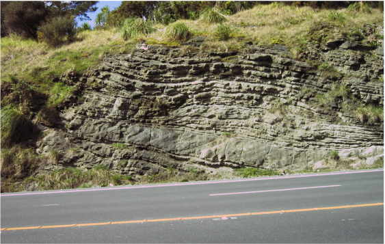
Waitemata sandstone strata exposed in road cutting at Pohuehue
I think of the three sedimentaries as being separated in age by a factor of about 3. The youngest are the sandstones laid down about 20 million years ago. They are visible as the light brown, tan or rust-coloured cliffs at Mullet Point beyond Bethshan and in some places on the Beach itself at Algies when the sand is “out”. These rocks are referred to as Waitemata Group in geological publications, and the ones at Algies and nearby more specifically as Pakiri Formation of Waitemata Group.
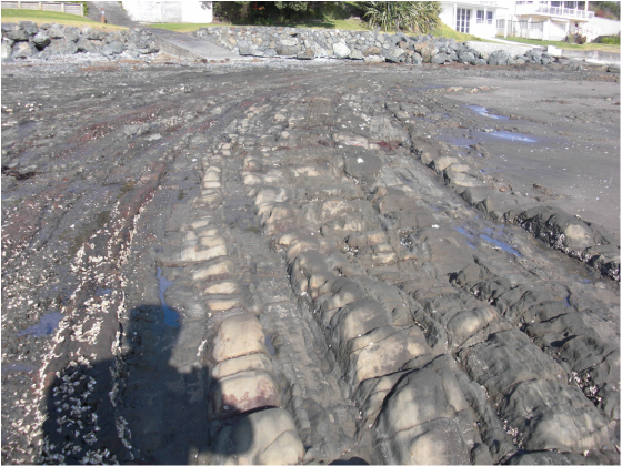
Waitemata Group sandstone strata upended, ie rotated through 90 degs.
The second is 60 million year old siltstones which oddly lie immediately below the topsoils and subsoils in Algies and Snells, and therefore above the 20m year old sandstones. The siltstones were laid down about 3 x 20 = 60m years ago - not quite long enough ago to include dinosaur bones! They are labeled Mangakahia Complex and belong in a “big bag” commonly referred to as Northland Allochthon - formerly Onerahi Chaos Breccia. I will just call them "the siltstones" because for most of us their age is not the important thing about them. The fact that they’re siltstones means that some of them undergo very rapid disintegration by a process known as “mechanical slaking” when dried and then re-wet, see below.
The third is greywacke which is found on much of Kawau and Takatu Point, in Christian Bay and also at Leigh and over the hill from Matakana where it is quarried for aggregate, road metal etc. It was laid down a bit more than 3 x 60 = 180m - 220m years ago. It is labelled Waipapa Group on geological maps.
Much of the axial range of NZ – the Southern Alps, Rimutakas, Tararuas, Ruahines - is greywacke, appearing as gravels in the beds of the rivers flowing from those ranges to the sea, and also in Hawkes Bay, the Wairarapa, Canterbury and Westland. Those areas have more than enough greywacke available for concrete and road metal. Here it is scarce and expensive because Kawau and Takatu can’t be quarried and the pockets of it over in Whangaripo Valley are small and there’s the cost of hauling it over the hill. The lake at Christian Bay was formed in the 1950’s by contractors barging it to Auckland to make the concrete piers for the Harbour Bridge.
Waitemata rocks are not hard enough (old enough) for use on roads or in concrete and the siltstones disintegrate on drying and re-wetting so greywackes are precious. What's quarried out of the greywackes are seams of volcanic rock - basalt or andesite - interspersed with sedimentary rock. Basalt is also quarried locally from lumps of Tangihua Formation rafted along by ancient submarine landslides that scrunched up the Mangakahia Complex siltstones.
One has to go outside Kawau Bay to Ti Point or Little Barrier, Great barrier or the Coromandel Peninsula to find a fourth rock type - volcanic rocks and soils. At these places magma from the Earth’s core pushed through the much older sedimentaries - at Ti Point only about 7m years ago rather than 20, 60 and 220 million years. Little Barrier is even younger at a mere 2m years old.
A dozen or so small volcanic “bombs” may be seen at low tide near Bethshan. Reddish rock with lots of oysters on them.
The third is greywacke which is found on much of Kawau and Takatu Point, in Christian Bay and also at Leigh and over the hill from Matakana where it is quarried for aggregate, road metal etc. It was laid down a bit more than 3 x 60 = 180m - 220m years ago. It is labelled Waipapa Group on geological maps.
Much of the axial range of NZ – the Southern Alps, Rimutakas, Tararuas, Ruahines - is greywacke, appearing as gravels in the beds of the rivers flowing from those ranges to the sea, and also in Hawkes Bay, the Wairarapa, Canterbury and Westland. Those areas have more than enough greywacke available for concrete and road metal. Here it is scarce and expensive because Kawau and Takatu can’t be quarried and the pockets of it over in Whangaripo Valley are small and there’s the cost of hauling it over the hill. The lake at Christian Bay was formed in the 1950’s by contractors barging it to Auckland to make the concrete piers for the Harbour Bridge.
Waitemata rocks are not hard enough (old enough) for use on roads or in concrete and the siltstones disintegrate on drying and re-wetting so greywackes are precious. What's quarried out of the greywackes are seams of volcanic rock - basalt or andesite - interspersed with sedimentary rock. Basalt is also quarried locally from lumps of Tangihua Formation rafted along by ancient submarine landslides that scrunched up the Mangakahia Complex siltstones.
One has to go outside Kawau Bay to Ti Point or Little Barrier, Great barrier or the Coromandel Peninsula to find a fourth rock type - volcanic rocks and soils. At these places magma from the Earth’s core pushed through the much older sedimentaries - at Ti Point only about 7m years ago rather than 20, 60 and 220 million years. Little Barrier is even younger at a mere 2m years old.
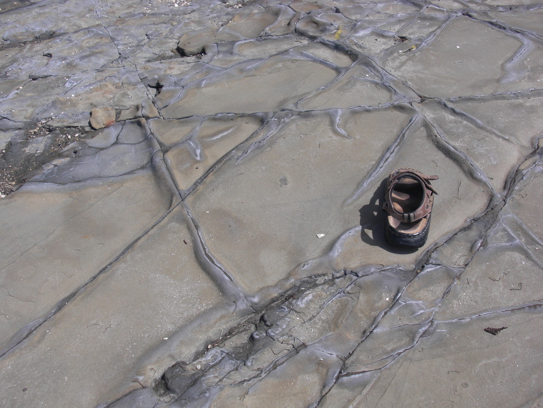
A dozen or so small volcanic “bombs” may be seen at low tide near Bethshan. Reddish rock with lots of oysters on them.
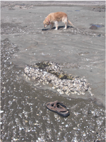
Volcanic “bomb” (above sandal) from submarine eruptions carried along in sea-bottom lahars during the Miocene
ie 5.3 to 24m years ago, (from sea-floor vents west of Auckland).
ie 5.3 to 24m years ago, (from sea-floor vents west of Auckland).
The different rock types have very different engineering properties. Only the greywackes are hard and stable enough to be used for concrete and roads. Some large blocks of greywacke have been brought to Algies from a quarry to provide protection for lawns and gardens just above high-tide level. They are dark grey and slightly shiny. They are “visitors”.
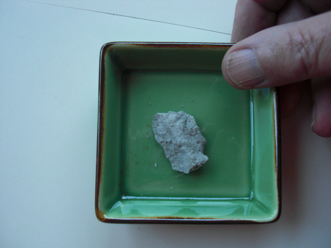
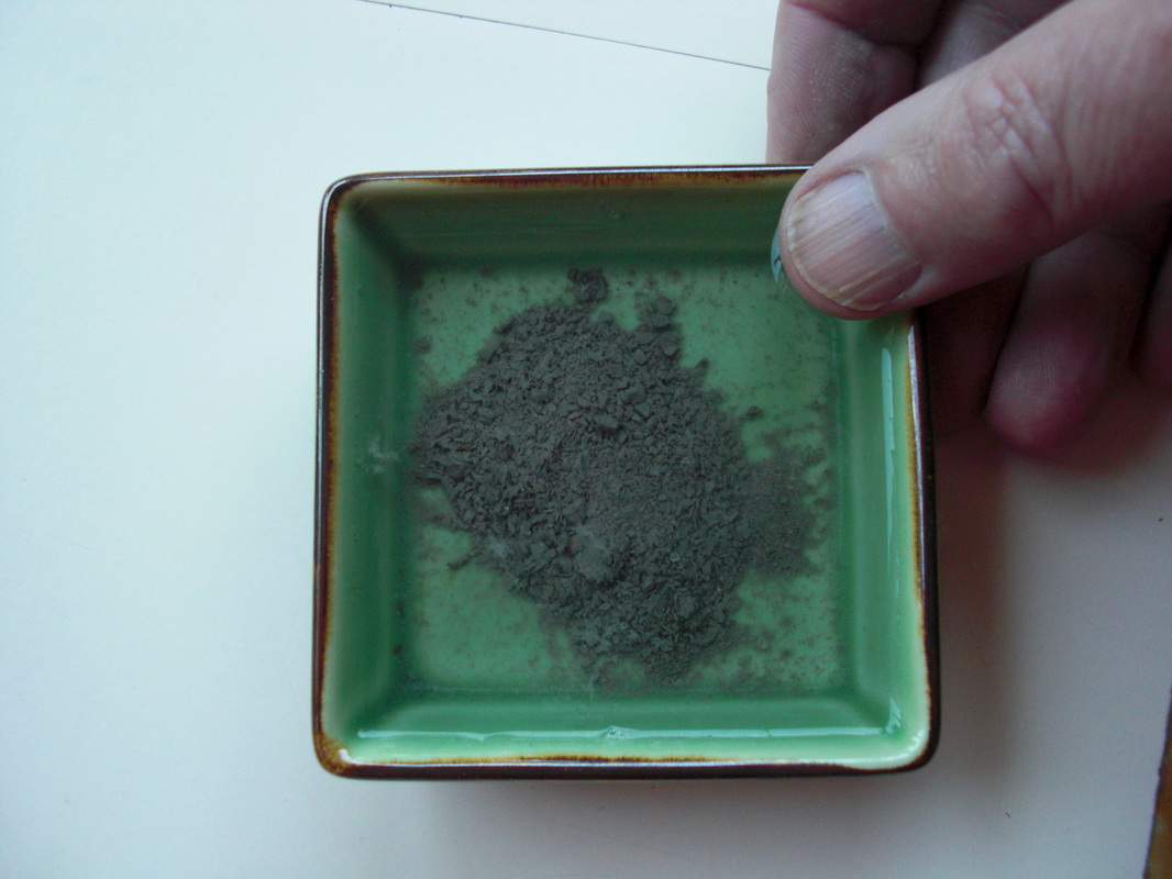
The 60m-yr-old siltstones are found below the ground surface immediately beneath the soils in the urbanized area at Algies. Most are very hard in their grey unweathered “original” state a few metres below the surface, but they have the disarming property of disintegrating and reverting to silt if they are dried and then re-wet. This makes it unsuitable for concrete or roading or just about anything. The disintegration process is called mechanical slaking. As soon as they are re-wet they disintegrate into silts very like the grey silts seen on TV being shoveled after the liquefactions in Christchurch and Kaiapoi.
|
|
Mechanical slaking (disintegration) of siltstone when allowed to dry and then re-wet
I hasten to add that our ones won’t liquefy because they are very dense and hard whereas the ones in Chch and Kaiapoi were “cardhouses” of silt particles at very low/weak densities. Silts are the finest particles which can be created by mechanical action: chemical action (weathering) is required in order to turn them (or any rock) into clay.
An interesting result of slow mechanical slaking may be seen on the beach between Bethshan and the large grassed landslip deposit with distorted Pohutukawas on it.
“Dishes” on siltstone surface
|
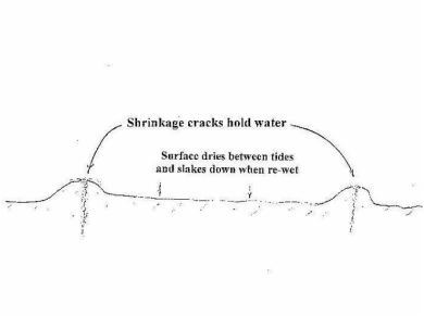
Cross-section of “dishes”
|
The edges of the dishes are higher than the rest. Water retained in the shrinkage cracks prevents the stone adjacent to them drying between tides and therefore prevents mechanical slaking.
Disintegration of the siltstones evidently begins with shrinkage cracks forming and dividing the rock into blocks. Because water is held (by meniscus forces) in these cracks after the tide recedes, the sides of the cracks don’t dry before the tide returns. That part of the siltstone does not therefore undergo the disintegration (mechanical slaking) which occurs on the surface of the rock away from the cracks, so the crack survives on a ridge of siltstone.
A variant of these 60m year old rocks forms White Bluff between Algies and Snells beaches. It has however a different chemical makeup which gives it its white colour and it is NOT susceptible to mechanical slaking. That may well be why White Bluff has survived while the (grey) siltstones either side of it have disintegrated (slaked) to form the urbanized slopes at Algies and Snells.
Once disintegrated, the silt grains become weathered (dominantly by the oxygen in groundwater seepages) to form rust-coloured subsoils. The products of weathering include iron oxide (common rust and several other iron oxides including a red one).
In some places the 60m yr old siltstones have 20m yr old Waitemata Group rocks beneath them! Younger sedimentary rocks are of course always laid down over older rocks, so one must expect rocks to be older as one looks deeper. This existence of younger rocks under older ones has been deduced to be the result of very ancient submarine landsliding (see above).
It is now known that the whole skin of the Earth (land masses and seabeds) are slowly being moved on top of hot viscous tar-like magma, like skin on custard. The “red hot” magma moves as convection currents (like water in a saucepan on a hot stove, ie the hotter masses move up and cool under the crust (skin) and then move down again. As they turn around, immediately beneath the solid crust, they push the crust and cause distortions and movements of the crust. Faults form separating masses which are wanting to move by different amounts (vertically and/or horizontally). Over time the relative movements include periods of "stick" and moments of "slip". The latter are felt as earthquakes. Rates of movement of a few millimeters per year are common, and that means a few km in each million years (!)
Movements of the crust include tiltings as well as slidings of originally horizontal layers of sediments deposited on the ocean floor. The tilting may add up to strata becoming vertical as may be seen on the Beach below 14 Gordon Craig Place, see photo (above) of Waitemata Group strata upended ie rotated through 90 degrees. The 60m yr old siltstones which were probably on top of them have been eroded /slaked away. The sliding and tilting may include folding and breaking.
In many places along the Beach, large, hard, dark grey “greywacke” boulders have been placed above the high water mark to inhibit erosion of the soils on properties. These “visitors” have been imported from quarries such as Whangaripo. They have generally been successful but their dark colour means their upper surfaces get hot in the sun and expand. Their shaded undersides and interiors remain cold so the top layers no longer “fit” the lower parts and large shearing forces develop within the rock mass. Where the planes of shearing forces coincide with ancient “seams” in the sedimentary rock they may break. The two parts may then rotate a bit and other surfaces become exposed to the warming of the Sun, - and so the process continues, decade after decade, and what was placed as a large boulder becomes many smaller rocks. Because Greywacke is hard the pieces remain sharp for a long time and are therefore not welcome on the Beach.
The most important thing to know about the rocks is not their ages or names but the fact that they behave differently and in particular one of them, the siltstone, is much much more prone to mechanical slaking than the others.
John Hawley 2015
